| |
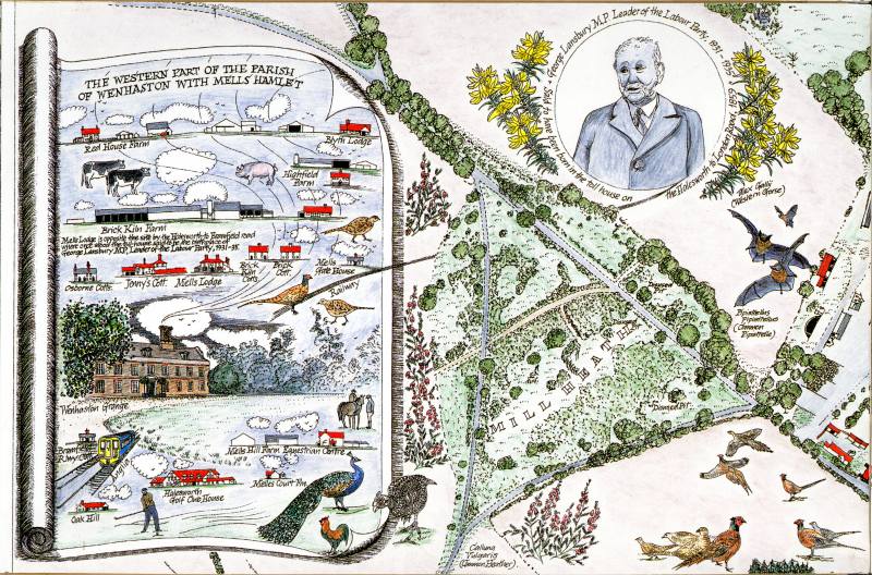
Wenhaston Millennium Map - Panel
A5 |
|
| |
 |
|
|
|
 |
| |
 |
|
| |
[Back to Main Map] |
|
| |
The Western Part of the Parish - The limited area selected for this map includes the main part of the village in the eastern half of the parish. The inset shows the buildings in the west of the parish.
George Lansbury - Appropriately the vignette of George Lansbury is linked to the inset showing the west of the parish by the illustration of the Anglia Railway. George Lansbury was born in 1859, his father being timekeeper for the contractor building the East Suffolk Railway through Halesworth. The contractor's workers lived in a hutted camp. The great-grandparents of Heather Phillips (Wenhaston Map Maker and Vice-Chairman of Wenhaston Parish Council) were concerned that George's mother should give birth in more salubrious circumstances and moved George's family into the toll house where they lived, near the railway. By reference to a tithe map and lists of landholders, the researches of the Wenhaston Map Makers indicated that the toll house was located on the turnpike from Halesworth to Bramfield at the south-west side of the crossroads with the Mells to Walpole road, within the parish of Wenhaston. It would seem therefore, despite a plaque on a building stating that he was born in The Thoroughfare, Halesworth, George Lansbury was born in the parish of Wenhaston. This appears to be confirmed by his recollections of his family history and an entry in Encyclopaedia Britannica, which records that he was born near Halesworth, Suffolk. The confusion about George Lansbury's place of birth is explained by Michael and Sheila Gooch in their book 'The People of a Suffolk Town'. Apparently, this was due to inaccurate registration of the birth when the Lansburys were living in Halesworth some weeks later.
George Lansbury's career included periods as Mayor of Poplar, M.P.for Bow, Editor of the Daily Herald, Chairman of the Labour Party, Minister of Works, and Leader of the Labour Party 1931 - 1935. He died in 1940.
|
|
| |
To
view any part of this panel in more detail just click on the area
you want to see
and a larger scale version will come up. Each panel like this has
nine enlarged sections.
To move to the next main panel in any direction just click on the
arrow to move up, down, left or right.
|
|
| |
This
map was made by the people of Wenhaston and Mells to mark the second
Millennium, to show thier appreciation of the local environment, and
to promote interest, concern and care for its well being. The pupils
of Wenhaston School made the wildlife decorative border of the map.
The entire map is the copyright of the Wenhaston Commons Group and
may not be copied with out permission. |
|
|